|
|
|||||||


 |
|
 12-30-2018, 08:44 PM
|
|||
|
The Wary
Forum posts: 0
File comments: 6
Uploads: 0
|
Hey, thanks for the solid answer and sorry for my late response. Yes, it seems like I have a different use case.
Given the breeland zone: https://i.imgur.com/6Pm83cK.png We have 2 colors here used in my drawing, yellow and red. I used red to mark zones and slayer deeds I have not completed yet. Since I want to complete all of them, I want to have an efficient way to tackle the problem at hand. I'm only interested in exploration markers and deed numbers while in this mode. In example, I would like all deeds annotations and exploration markers that are _not_ in the red circles to not show up (even if that meant manually clicking them all the other deed markers to go away, since there is no API to query whether someone has completed a deed or not). When I only see the deeds I have to do, I can trace a path to make deed completion a less ardous task, as I only have to check the deed log once to disable the deeds I'm not interested in (i.e. already done), rather than have to check over and over to see which ones I have left. Switching between MoorMap and the actual map to see what's left to do is friction. So, I would count this as: remove things I've done from the map. Then, we get to the yellow color. When I only see the deeds I have left to do, I can simply trace the yellow path mentally when I see only 'interesting' nodes, not everything. On a more advanced level, it would be nice to have a button that traces a shortest path via dijkstra or the like, for you with the given visible markers. |
||


|


|
|
12-16-2018, 10:30 PM
|
||||
|
The Undying
Forum posts: 341
File comments: 980
Uploads: 20
|
Quote:
Deeds can often refer to things that occur in a large part of the map or at (or very near) a group of distinct locations. In the former case, Overlays are the best solution as they can be used to indicate a large area of a map in which a deed can be completed (see Berry's Deed Data overlay examples). In the latter case , which I now assume you are interested in, you are looking for one or more Annotations which might be obscured by other nearby Annotations. While there is indeed no way to hide all but a single annotation, there IS a means of temporarily highlighting either 1) a specific Annotation or 2) the location of a specific Annotation. I make the distinction because in the first case you still see all of the annotations, in the second case, you suppress some or all annotations to make the marked location easier to spot. In both cases you use the Local Search, accessed by the silver (or greyish) magnifying glass at the top of MoorMap, fourth button from the left. For instance, if you are looking for the flowers in the Old Forest deed and show the Breeland map (I know the Old Forest has it's own less cluttered map, but Breeland is used for the sake of demonstrating finding a single annotation in a larger clutter). Below is a screenshot of the Breeland map with all annotations showing: Fig 1 (click the image to see full size):  ScreenShot00375 ScreenShot00375If you click on the silver magnifying glass, it opens a panel on the right side with a filter box at the top. Type in the name (or part of name) of the annotation you are looking for - in this case I typed 'dor' to find Dorollin's Flower. The list of annotations will be reduced to those matching the typed text. Fig 2: 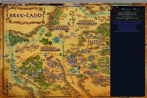 ScreenShot00377a ScreenShot00377aIf you now click on the entry for Dorollin's Flower, a 'ping' (an animated expanding circle) is displayed at the coordinates of that annotation (look at the lower left area just above the text for Withywindle Crossing - the animated version is easier to spot) Fig 3: 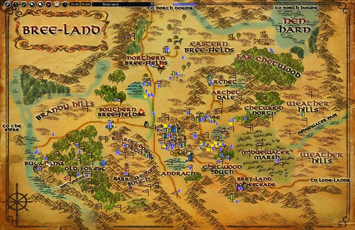 ScreenShot00376 ScreenShot00376If you can't spot the animated ping, then you can use the second option which is to filter out the annotations by clicking the filter button (looks like a circle with red and green dots above a separator and just red below it), third button from the left top corner of MoorMap. I selected 'Clear All' to make the ping far more visible, you can clearly see one of the animated rings in the lower left corner (again the actual animated ping is far easier to spot). Fig 4: 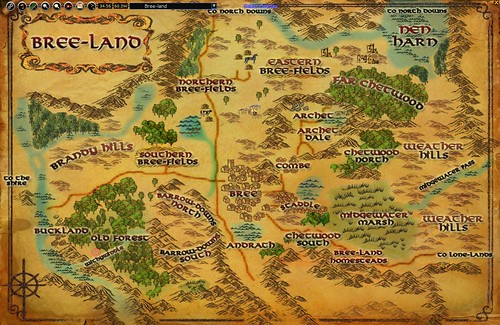 ScreenShot00377 ScreenShot00377FWIW, I did consider making the annotations subject to the filtering of the local search panel but testing indicated it significantly impacted the performance of the filter text box, especially on lower end systems. I also considered adding an "update filter" button to apply the filter but it just didn't seem worth the time for what was essentially very little gain in functionality over the existing functionality. |
|||

|
|
|
12-16-2018, 08:18 PM
|
|||
|
The Wary
Forum posts: 0
File comments: 6
Uploads: 0
|
I think I was referring to the overlay in a wrong manner, I meant individually hide each marker from the UI.
|
||
|
|
|
|
12-16-2018, 07:56 PM
|
|||
|
The Wary
Forum posts: 0
File comments: 6
Uploads: 0
|
I've tried looking around and I can't find any way to toggle visibility of just _one_ overlay. Let's say I'm doing deeds in one area, and I've explored all but 2 overlays. I would like to manually toggle off other overlays while I work on getting the deed for those two. I might have missed it in the UI.
Through my short read of the source code, I did not find that functionality and was wondering if you wanted me to submit a patch with that functionality implemented. |
||
|
|
|
|
12-15-2018, 09:40 PM
|
||||
|
The Undying
Forum posts: 341
File comments: 980
Uploads: 20
|
Re: Contribution
Quote:
Note: IIRC, the floating 'Legend' and data driven capabilities of the Berry's Deed Data Overlays is still hardcoded and not available for user defined Overlays so if you want a Legend you will have to include it in your transparency (it's been a number of years since I implemented the Overlays so I don't recall whether user defined Legends were ever implemented - they were on the ToDo list but kept getting bumped down due to other more important updates). Since MoorMap is basically in a maintenance mode, I don't foresee any real functional changes - map updates and simple content updates such as user generated Overlays yes, new functionality, no. As evidenced by the fact that the U23 update hasn't even gotten published yet, MoorMap is unfortunately a fairly low priority right now (RL and other projects keep getting in the way). Last edited by Garan : 12-15-2018 at 10:16 PM. |
|||
|
|
|
|
12-15-2018, 11:50 AM
|
|||
|
The Wary
Forum posts: 0
File comments: 6
Uploads: 0
|
Contribution
Hey, mind if I contribute a patch that allows hiding/showing specific overlays? Since the API doesn't allow querying quest/deed status, maybe users manually ticking visibility of overlays or graying them out would help with deed hunting.
|
||
|
|
|
|
12-06-2018, 10:22 PM
|
||||
|
The Undying
Forum posts: 341
File comments: 980
Uploads: 20
|
Re: Update for The Grey Mountain
Quote:
|
|||
|
|
|
|
12-06-2018, 07:24 PM
|
|||
|
The Wary
Forum posts: 0
File comments: 73
Uploads: 0
|
Update for The Grey Mountain
Heya
I like this plugin and I am wondering if any update for The Grey Mountain is comming? Last edited by Jethpriel : 12-06-2018 at 07:25 PM. |
||
|
|
|
|
07-12-2018, 05:29 AM
|
||||
|
The Wary
Forum posts: 0
File comments: 2
Uploads: 1
|
Re: Re: Adding the /MoorMap add ;loc:55::;target to a hotkey
Excellent! This worked perfectly! Thank you so much.
Quote:
|
|||
|
|
|
|
07-11-2018, 11:57 AM
|
||||
|
The Undying
Forum posts: 341
File comments: 980
Uploads: 20
|
Re: Adding the /MoorMap add ;loc:55::;target to a hotkey
Quote:
What you need to do is prevent the ";loc" from resolving when the command is added so that it will then resolve when the key is pressed. You can do this using an alias. It's been a couple of years since I played with this so I'll double check it in-game and post an edit to this post with the exact commands to enter. EDIT: OK, using the alias is pretty simple but slightly non-intuitive. The chat commands are: Code:
/alias ;zzz loc /shortcut 1 /moormap add ;;zzz:55::;target /alias remove ;zzz The second line creates the shortcut for the built in quickslot. Since you have to reference aliases with a semicolon character, the shortcut assignment has two semicolons before 'zzz', one to reference 'zzz' and resolve it to 'loc' while assigning the command and the other to reference the 'loc' to resolve when executing the command. The third command simply removes the zzz alias since it is no longer needed once the shortcut is assigned. P.S. Also make sure you don't have anything targeted when assigning the key, otherwise the ;target will resolve prematurely causing a similar issue. For ;target, all you have to do is make sure you have nothing targeted while assigning the command - the ;loc is a bit trickier since you always have a location. Last edited by Garan : 07-12-2018 at 06:23 AM. |
|||
|
|
|
|
07-11-2018, 11:16 AM
|
|||
|
The Wary
Forum posts: 0
File comments: 2
Uploads: 1
|
This is an awesome plugin. I don't know how I have played for seven years without it. Even after using plugins for five years!!!
Ok, this is probably something I'm doing wrong, not a bug with the plugin, but I don't know how to fix it. When I run this command: /shortcut 1 /MoorMap add ;loc:55::;target I get this result: [07/11 11:12:31 AM] Shortcut to '/moormap add Rhovanion: Thinglad: 24.7S, 61.1W:55::;target' added in location 1. Obviously, this is not what I want.  How do I stop it from interpreting loc:55 as my current location and coordinates and put exactly ;loc:55 into my shortcut? How do I stop it from interpreting loc:55 as my current location and coordinates and put exactly ;loc:55 into my shortcut? I run with an MMO mouse with a billion buttons, and so having to use the flag button on the UI is just less convenient for me. I can't seem to drag the button and drop it onto a quickslot either. |
||
|
|
|
|
04-25-2018, 06:52 AM
|
|||
|
The Undying
Forum posts: 341
File comments: 980
Uploads: 20
|
I just fixed the copy/paste error in the version log for 1.36. Thanks Thurallor for pointing that out.
|
||
|
|
|
|
04-11-2018, 08:59 AM
|
|||
|
The Undying
Forum posts: 341
File comments: 980
Uploads: 20
|
The error reported by Invizet is caused by a bug specific to loading the Ettenmoors map with the Russian language selected. If anyone else has run into this error, you can simply change the line at or just prior to (depending on your version) line 1086 that reads:
Code:
if _G.tmpMapString~=nil and type(_G.tmpMapString)=="table" then Code:
if _G.tmpMapString~=nil and type(_G.tmpMapString)=="table" and _G.tmpMapString[Settings.language]~=nil then Last edited by Garan : 04-11-2018 at 09:01 AM. |
||
|
|
|
|
04-08-2018, 05:11 PM
|
||||
|
The Undying
Forum posts: 341
File comments: 980
Uploads: 20
|
Re: Error
Quote:
Also, could you clarify what you mean by the "russian ex-version" of MoorMap? Do you mean you last used MoorMap with the RU lotro client before it was discontinued? Or were you using a modified version of MoorMap? The solution may be the same either way, I would just like to have an idea of how many others may be affected in case others run into the same problem. |
|||
|
|
|
|


All times are GMT -5. The time now is 08:29 AM.
|
© MMOUI
vBulletin® - Copyright ©2000 - 2024, Jelsoft Enterprises Ltd. |